


|
Name |
GPS Map Camera |
|---|---|
|
Google Play Link |
GET IT ON
Google Play
|
|
Category |
Photography |
|
Developer |
GPS Map Camera |
| Last version | 1.9.17 |
|
Updated |
|
|
Compatible with |
Android 6.0+ |
What is GPS Map Camera APK?
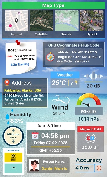
GPS Map Camera is a mobile utility tool designed for Android devices that helps users geotag their photos with real-time location data. Unlike a regular camera app, this one adds detailed geographic and environmental information to each photo the moment it’s taken. This includes latitude, longitude, address, weather, compass direction, altitude, and even magnetic field details, all stamped directly onto your pictures.
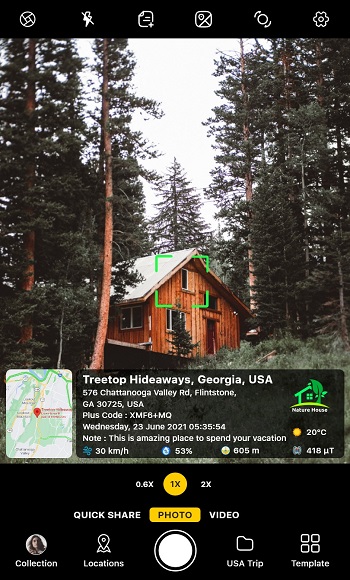
The app serves one main purpose: to visually document the where and when of every photo. Whether you’re documenting fieldwork, construction sites, travel spots, or just want to remember exactly where a picture was taken, this app automatically embeds all that context into the image. It’s especially helpful for professionals who rely on verified data, like real estate agents, engineers, and surveyors.
Users can choose from a variety of customizable stamp templates. Some prefer a simple timestamp and location overlay, while others go full detail with maps, coordinates, and environmental data. The app even supports map view customization you can switch between satellite, hybrid, terrain, or standard views to suit your style.
What makes it practical is how smooth it feels in use. You can tweak font colors, sizes, and stamp positions to avoid covering important parts of the photo. It also offers built-in support for selfies, filters, gridlines, and camera adjustments like white balance and flash. This makes it more than just a GPS tagger it’s a handy all in one camera app with a built-in documentation layer.
There are some minor downsides, though. While it’s feature-rich, the interface can feel slightly overwhelming to first-time users because of all the toggles and options. And since it relies on real time GPS and weather data, it’s best used outdoors or with strong signal reception to avoid inaccuracies.
GPS Map Camera works best for people who value accuracy and accountability in their photo records. From travel bloggers capturing every stop to project managers needing photo documentation, this app fits into both personal and professional routines with ease.
FAQs GPS Map Camera
What is GPS Map Camera?
+
GPS Map Camera is a mobile app for Android that automatically adds GPS coordinates, date, time, and other environmental data to your photos.
How does GPS Map Camera work?
+
The app uses your phone’s GPS and sensor data to embed real-time information like latitude, longitude, weather, and compass direction into each photo.
Can I customize the GPS stamp on my pictures?
+
Yes, you can change the font, color, stamp position, and choose what data to include, like maps, timestamps, or custom logos.
Is GPS Map Camera useful for professionals?
+
Definitely. It's widely used by real estate agents, field engineers, site inspectors, and others who need photo evidence with verified locations.
Does GPS Map Camera require internet access?
+
It works best with GPS and data enabled, especially for live weather or map features, but it can still stamp location offline using cached data.
Discover More Interesting Apps
-
 Mod
Mod
PhotoRoom
v2026.22.03
147.82 Mb
Updated -
Mod
Lensa
v6.3.2+865
148.53 Mb
Updated -
Mod
AirBrush
v8.9.0
424.95 Mb
Updated -
Photo Lab PRO Picture Editor
v3.13.77
35 MB
Updated -
AI Marvels
v2.4.0
184.26 Mb
Updated -
Mod
Hypic
v8.7.0
265.38 Mb
Updated -
Mod
Clone AI
v8.8.0
98.46 Mb
Updated -
Mod
PREQUEL
v2.1.0
144.28 Mb
Updated -
Mod
LightX Pro
v2.5.6
146.16 Mb
Updated -
Mod
Timemark
vv10.0.135
131.00 Mb
Updated
Share Your Thoughts